Heat island effect explained
The Scorching Truth: Why Our Cities Are Overheating and How We Can Cool Them Down
Have you ever stepped into the heart of a bustling city and felt an immediate surge of heat, a distinct difference from the cooler, quieter areas just beyond its edges? You’re not imagining it. This phenomenon is known as the Urban Heat Island (UHI) effect, a growing challenge our cities can no longer afford to ignore.
The UHI effect describes a striking temperature differential: urban areas consistently bake at significantly higher surface and air temperatures than their surrounding rural landscapes. Why does this happen? It’s a perfect storm of human activity and design choices. We’ve built cities with vast expanses of dark, impervious surfaces like asphalt and concrete, which are excellent at absorbing and retaining solar radiation. We’ve also dramatically reduced vegetation cover, cutting down on nature’s cooling power through evapotranspiration. Add to this the heat spewed out by our buildings, vehicles, and industries, and you have a recipe for a warmer, more uncomfortable urban environment. This alters the city’s energy balance, leading to hotter days and, critically, hotter nights, fundamentally changing local microclimates.
The Dangerous Reality of Rising Urban Temperatures
The consequences of UHI are far-reaching and severe. It relentlessly exacerbates energy demand, forcing air conditioners to work overtime and straining power grids. It worsens air pollution, as higher temperatures can accelerate the formation of ground-level ozone. Most critically, UHI intensifies during heatwaves, transforming already dangerous conditions into life-threatening ones, disproportionately impacting vulnerable populations and deepening social inequality.
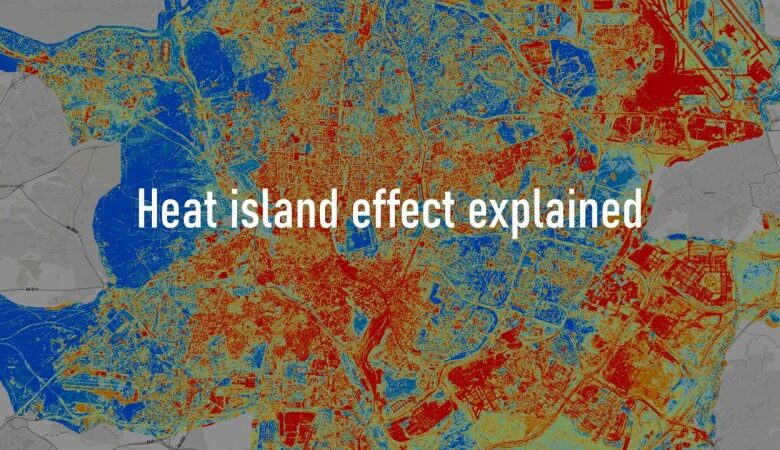
Just look at Madrid. The image below, a 2022 thermal map, paints a vivid picture: the city center, ablaze in red, registers significantly higher surface temperatures compared to the cooler, serene blue of its parks, gardens, and less built-up zones. This visual evidence isn’t just striking; it’s a powerful call to action, highlighting the urgent need for robust adaptation strategies.
Madrid Takes a Stand: A Blueprint for Cooler Cities
The good news is, cities like Madrid are not passively accepting this scorching fate. They’re actively fighting back! Madrid is embracing a proactive approach by:
- Deploying green corridors: Weaving ribbons of vegetation through the urban fabric.
- Planting urban forests: Creating lush, natural havens within the concrete jungle.
- Promoting sponge parks: Innovative public spaces that combine strategic planting with smart water management, transforming them into cooler, more breathable refuges for residents.
These initiatives are not merely aesthetic; they are vital pieces of a larger puzzle, actively creating cooler, more resilient public spaces that benefit everyone.
Our Collective Call to Action: Cooling the Urban Core
The battle against UHI requires collective effort and innovative thinking. What concrete steps can we take to cool down our cities?
- Swap Asphalt for Light & Permeable: Replace dark, heat-absorbing asphalt with lighter-colored, permeable surfaces that reflect sunlight and allow water to seep into the ground, naturally cooling the area.
- Embrace Trees and Urban Greenery: Prioritize planting trees and expanding urban greenery wherever possible. Trees provide crucial shade and cool the air through evapotranspiration.
- Design Public Spaces as Climate Refuges: Intentionally design parks, plazas, and other public areas with features like ample shade, water elements, and cooling materials to offer respite during extreme heat events.
- Integrate Nature-Based Solutions into Planning: Make nature an integral part of urban planning from the outset, using green roofs, vertical gardens, and permeable pavements to mimic natural processes and enhance urban resilience.
source:
Temukan peta dengan kualitas terbaik untuk gambar peta indonesia lengkap dengan provinsi.


