Why every city can benefit from a ‘15-minute city’ vision
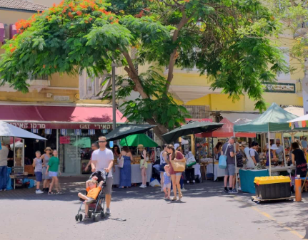
A Strategic Vision for Urban Transformation
The 15-minute city is a human-scale urban design framework centered on accessibility, proximity, and community vitality. Its core goal is to enable every resident, in every neighborhood, to access their daily essential needs such as fresh food, education, healthcare, green space, and recreation—within a short walk or cycle ride from home.
By decentralizing services and shifting away from a century of car-centric urban sprawl, this model transforms single-use zones into vibrant, interconnected, and resilient “complete neighborhoods.”
The Strategic Value Proposition
                                 THE 15-MINUTE CITY MODEL
┌─────────────────────────────────────────────────────────────────────────────────────────┐
│                                HUMAN-SCALE NEIGHBORHOOD                                 │
│    [Housing] ─── [Local Retail] ─── [Parks & Healthcare] ─── [Schools & Public Spaces]   │
└────────────────────────────────────────────┬────────────────────────────────────────────┘
                                             │
             ┌───────────────────────────────┼───────────────────────────────┐
             ▼                               ▼                               ▼
   ECONOMIC VITALITY                 COMMUNITY EQUITY                 PUBLIC HEALTH
Local footfall, diverse jobs,     Priority for under-served         Clean air, active travel,
and small business growth         areas & accessible design          reduced urban heat island
1. Economic Acceleration
- High Street Revitalization: Bringing daily services closer to homes drives local footfall, directly benefiting small businesses, independent retailers, and local entrepreneurs.
- Productive Space Utilization: Mixed-use zoning allows buildings and public space to serve multiple functions throughout the day (e.g., schoolyards operating as public parks after hours).
- Job Diversification: Micro-economies generate local employment opportunities, keeping capital circulating within neighborhood communities.
2. Social Equity & Inclusivity
- Closing Service Deserts: The model explicitly prioritizes historically under-resourced and peripheral neighborhoods to ensure equal access to infrastructure and essential services.
- Universal Accessibility: Streets and active transport lanes are engineered to accommodate vulnerable urban dwellers, including children, older adults, and individuals with mobility challenges.
- Fostering Social Cohesion: Public spaces, parks, and pedestrianized streets create natural gathering spaces that strengthen community bonds and combat urban isolation.
3. Environmental Resilience & Health
- Modal Shift in Transport: Replacing short, car-dependent trips with active travel (walking and cycling) significantly lowers greenhouse gas emissions and vehicle air pollution.
- Climate Adaptation: Integrating green infrastructure such as street trees, bioswales, and pocket parks mitigates the Urban Heat Island (UHI) effect, improves stormwater management, and enhances urban biodiversity.
- Preventative Healthcare: Increased physical activity and reduced stress from long commutes yield measurable improvements in physical and mental well-being.
Global Nomenclature: One Vision, Many Contexts
While popularized globally by Paris Mayor Anne Hidalgo and urban scholar Carlos Moreno, the principles underlying the 15-minute city are adaptable across diverse geographic, cultural, and political settings:
| Location | Local Terminology | Primary Focus |
| Paris, France | La Ville du Quart d’Heure | Repurposing street parking into green spaces and active transport lanes. |
| Portland, Oregon, USA | Complete Neighborhoods | Ensuring 90% of residents can meet basic non-work needs locally. |
| Bogotá, Colombia | Barrios Vitales | Integrating care services and public space upgrades in low-income districts. |
| Melbourne, Australia | 20-Minute Neighbourhoods | Suburban retrofitting to promote local living and active transit connections. |
| Barcelona, Spain | Superblocks (Superilles) | Reclaiming interior street grids for pedestrian use and local commerce. |
How Cities Implement the Framework
The 15-minute city is not a rigid template; it is an overarching framework that unifies a city’s sustainable transport, housing, health, and economic development strategies into a cohesive vision.
┌──────────────────────────────────────────────────────────────────────────────────────────┐
│                                FOUR CORE PILLARS OF ACTION                               │
├────────────────────────────┬────────────────────────────┬────────────────────────────────┤
│ 1. DATA & MAPPING          │ 2. REALLOCATING SPACE      │ 3. DECENTRALIZED SERVICES      │
│ Map existing assets to     │ Convert vehicle lanes into │ Shift city services, clinics,  │
│ identify service deserts.  │ wider sidewalks & bike     │ and community hubs into local  │
│                            │ networks.                  │ nodes.                         │
└────────────────────────────┴────────────────────────────┴────────────────────────────────┘
- Asset Mapping & Gap Analysis: Cities begin by evaluating local amenities across all districts to identify areas lacking essential infrastructure (e.g., fresh food stores, transit stops, or primary care clinics).
- Street Space Reallocation: Transitioning street design away from private vehicle throughput toward safe, high-quality pedestrian zones, protected cycle paths, and reliable public transit links for longer journeys.
- Decentralized Service Delivery: Bringing municipal functions, health services, and cultural programs directly into neighborhoods via multi-use community hubs.
- Participatory Planning: Co-designing neighborhood interventions with local residents, business owners, and non-profits to reflect genuine community priorities.
Conclusion
The 15-minute city vision offers municipal leaders a flexible, proven blueprint for urban revitalization. By reorienting city design around human proximity rather than vehicular travel, cities can drive economic growth, improve public health, reduce carbon emissions, and build more equitable communities.